 Namibia Map
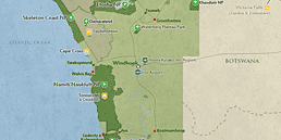
The Zambezi Region (formerly Caprivi Strip) is around 900km/560mi from the capital, Windhoek, by car. The area is a panhandle in northeastern Namibia, stretching roughly 400km/250mi from east to west and between 32km/20mi and 96km/60mi from south to north. The easternmost point is where the borders of Namibia, Zimbabwe, Botswana and Zambia meet.
For most travelers, the Zambezi Region is an access route for traveling from Namibia to Chobe National Park in Botswana or Victoria Falls in Zambia/Zimbabwe, and vice versa. The distance from Victoria Falls to the Zambezi’s eastern end is about 400km/250mi (driving time 4½ hours*). From Chobe it’s 380km/240mi (driving time 5½ hours*).
The main point of entry into Namibia is Hosea Kutako International Airport (WDH), 40km/25mi east of Windhoek. Visitors will usually start their trip by 4x4 vehicle in Windhoek. Alternatively, there are that take you between different parks by charter flight. Some travelers also fly into the safari gateway towns of Kasane or Maun in Botswana, and cross into Namibia from there.
*Driving times are only a rough indication. You should always consider the possibility of significant delays.
Airlines & Ticket Prices
Please check Skyscanner to see which airlines can take you to Hosea Kutako International Airport (WDH), and what tickets would cost.
Domestic Flights
Tour operators usually book charter flights between parks as part of the tour package.
- FlyNamibia (Offers domestic flights from Windhoek to the cities of Rundu and Katima Mulilo in the Zambezi Region)
Passport, Visa & Other Entry Requirements
Please check our How To Get to Namibia page to learn more about passport, visa and other entry requirements.